Integrated Geospatial Mapping Solutions for Planning, Siting, and Permitting Energy Projects
Discussing integrated geospatial mapping solutions for planning, siting, and permitting energy projects
Renee Walmsley, who leads Tetra Tech’s geomatic technologies group in North America, explores the applications and benefits of remote sensing and precision mapping technologies to streamline energy project planning, siting, permitting, and asset management.
Remote sensing and precision mapping technologies are being used to develop solutions for clients with complex planning, siting, and permitting challenges. New remote sensor technologies from airborne and mobile platforms enable more efficient and accurate data collection compared to traditional survey methods. Tetra Tech’s in-house remote sensing and geomatics team works closely with our scientists, planners, and engineers to meet project specifications in more efficient and technologically advanced ways.
Benefits of Sensor Technologies and Visualization Platforms
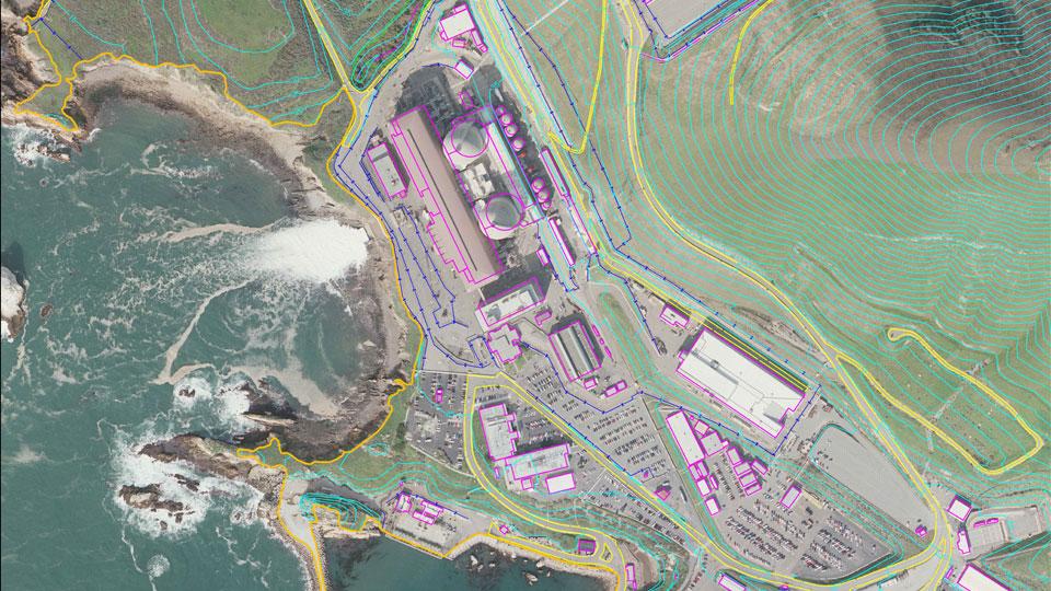
The introduction of high-resolution digital cameras and 3D scanning has revolutionized the field of surveying by enabling data to be collected quickly and precisely, driving timely and accurate decision-making. Tetra Tech uses the latest high-resolution sensors and laser scanning technologies for various airborne and mobile surveying needs to provide detailed topographic maps, 3D models, roadway condition and design, asset management, volume calculations, and more. Tetra Tech collects airborne imagery and light detection and ranging (LiDAR) data with unmanned aerial systems (UAS), fixed-wing aircraft, and helicopter platforms. We use the data as base maps and surface models for planning and siting projects as well as for asset mapping and design engineering. Imagery collected with multispectral and hyperspectral cameras allows for analysis of vegetation species for permitting activities. An airborne data collection approach can survey hundreds of square miles quickly and accurately.
Mobile LiDAR data collection and mapping products are more efficient than traditional surveys because they produce more accurate datasets with faster collection times. LiDAR gathers a complete point cloud dataset that the user can revisit later for additional data mining. This enables additional or follow-on work at the same project site. The LiDAR data is often used for facility mapping, precision topographic models, BIM models, and asset management. For most terrestrial LiDAR projects, we can provide our clients registration of the data immediately after scanning. Once we capture the data, it is very cost effective to process supplemental data as needed, without requiring additional site visits and field collections. This allows the data to be used through a project life cycle.
We recognize that many of our clients do not have the infrastructure and software to store and visually display remotely sensed data. We develop visualization platforms and tools for display of imagery and LiDAR data, change detection models, and derived analysis products. The benefit of providing these tools and platforms is that it drives timely and accurate decision making.
Integrating Remote Sensing and Mapping Technologies into a Project
To best serve our clients, Tetra Tech begins discussion of these technologies early in the project planning cycle. Our experts consider project size, location, and the required level of accuracy to assess whether remotely sensed data would offer a benefit to the project.
The project size determines the appropriate type of data collection platform and sensor. For airborne projects, the size of the project will determine if it is best suited for UAS, fixed-wing, or a helicopter platform. For example, a wide-area collection for siting a well pad or a topographic analysis may have a different sensor approach than a smaller 2-acre site. Linear corridor acquisition of data will have a different sensor approach than a wide-area collection as well.
The project location also plays a role in determining the type of data collection platform and sensor. Many projects require collection during specific windows, for example when equipment has been removed from a site, when tides are low, or when airspace is available. The flying height, topography, and vegetation at a particular location also determine the best sensor solution. For example, many locations within the Pacific Northwest have heavy vegetation cover. A LiDAR collection in this region may require a different sensor system and flying height than a less vegetated area within the southwest United States.
Accuracy of the project deliverables will determine the platform and sensor solution. The required project accuracy and accuracy of derived products will determine the time collecting the site, processing the data, and creating the derived data. Project accuracy ultimately determines the flying height of the sensor, the overlap of flight lines, and the sensor best suited for capturing the data. Many times, mapping products will require a stamp from a certified photogrammetrist to ensure standard mapping accuracies are met.
By implementing remote sensing and mapping technologies into projects early in the planning cycle, Tetra Tech saves our clients valuable project time. We provide accurate, precision mapping products and high-quality visualizations that enable our clients to confidently make decisions based on precise data.